SAROI @ CAST
The SAROI program is intended to make an extensive suite of instruments and expertise at the Center for Advanced Spatial Technologies (CAST) and the MicroCT Imaging Consortium for Research and Outreach (MICRO), University of Arkansas-Fayetteville.
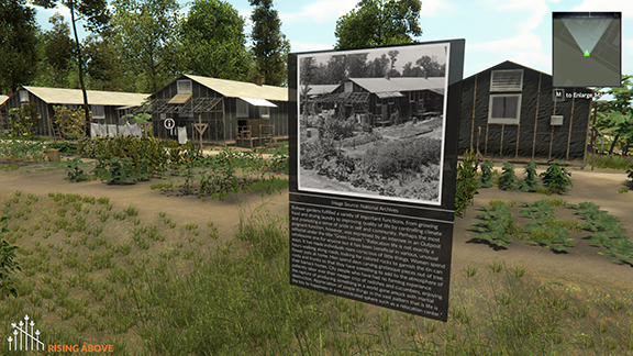
Over the past 28 years, researchers at CAST have made substantial investments in the development of capacities in geospatial technologies and promoted their use in archaeological and heritage research. These include projects such as Rohwer Reconstructed, an interactive digital archive and 3D reconstruction of a Japanese-American WWII internment camp in Arkansas; the Virtual Hampson Museum, allowing for remote access and research on artifacts from the Hampson Archaeological Museum State Park in Wilson, Arkansas; Spatial Archaeometry Research Collaborations (SPARC), a National Science Foundation program that has enabled geospatial applications into archaeological research since 2013; and The Corona Atlas Project, an open-access global imagery database that curates global orthorectified photos from the United States’ first photographic spy satellite mission, in operation from 1960-1972. Images from these various projects are found throughout the SAROI website.
Nested within and managed by CAST, MICRO is the home of the University of Arkansas’s micro computed tomography (microCT or µCT) system, MicroCT can be used for the quantification and visualization of objects representing cultural innovations through time. Archaeological projects at MICRO have include the imaging of a Native American woven bag from Edens Bluff Shelter, Arkansas, which was filled with Chenopodium berlandieri seeds; a 1,000 year old river cane flute from Breckenridge Shelter, Arkansas; and scanning of a Peruvian ceramic vessel that may be a whistling vessel. Other scanning applications can be found on the MICRO’s research page and on its Facebook and Twitter accounts.
Facilities
CAST (www.cast.uark.edu) was founded in 1991 as a research center in the University of Arkansas’s J. William Fulbright College of Arts and Sciences. It is dedicated to research and applications in geospatial analysis and modeling, enterprise spatial databases, remote sensing, digital photogrammetry and geospatial interoperability and has been selected as a Center of Excellence by Leica Geosystems, Intergraph Corporation, Oracle Corporation, Trimble Navigation Ltd., Trimble/Definiens Imaging Software, Safe Software, PCI Geomatics, eSpatial Systems and has be involved in a multi-year CRADA’s with ESRI.
CAST specializes in serving the academic community through its emphasis on high quality university courses in Geographic Information Systems (GIS), Global Positioning Systems (GPS), Unmanned Aerial Systems (UAS), remote sensing and photogrammetry, and 3D High Density Surveying from a variety of platforms. CAST is actively involved in extensive research efforts through multiple grants totaling more than $1.5 million awarded each year. The research efforts complement and greatly benefit the educational and public service focus by allowing staff and students to stay on the leading edge of emerging technologies as well as providing opportunity for economic development.
Equipment
CAST maintains extensive research computing infrastructure including: a suite of open-source scientific computing and development platforms and libraries; a multi-core large memory and GPU node dedicated to spatial data analysis in the Arkansas High Performance Computing Center; more than twenty 2D/3D processing and visualization workstations; 240+ TBs of RAID storage; and three systems administration staff to support these facilities. CAST has access to the full computing resources of the Arkansas High Performance Computing Center.
With support from multiple NSF awards (NSF BCS-1725925, BCS- 0321286, EPS-0918970) as well as university and other extramural sources, CAST has assembled a complementary and integrated suite of instruments and software that can be used to study the human past. These include equipment for surface reconstruction and morphometric analysis (i.e. 3D scanning and laser scanning), volumetric 3D imaging (i.e. microCT), archaeo-geophysics, aerial remote sensing and survey (i.e. UASs, or “drones” and their sensors), geodetic positioning and topographic survey (i.e. GPS), and visualization (AR/VR). The full list of CAST equipment can be found at https://cast.uark.edu/equipment/, with MICRO’s specifications at https://micro.uark.edu/micro-equipment/.
SAROI Staff
Carla Klehm: Klehm is the Project Director fand PI for SPARC at the University of Arkansas, an Adjunct Assistant Professor in the Department of Anthropology at the University of Arkansas, and a former NEH-IDA fellow. Klehm is an anthropological archaeologist who directs international, multidisciplinary projects that span from the outskirts of the earliest polities in southern Africa and the riverine fortress networks of Bronze Age Europe to mortuary assemblages at some of East Africa’s earliest megalithic monuments. Her research has incorporated a range of geospatial applications, including geophysics, sUAS sensors, and predictive modeling using multispectral satellite imagery.
Fred Limp: Limp is the Leica Geosystems Chair in Geospatial Imaging at the University of Arkansas, the Former Director of the Center for Advanced Spatial Technologies (1991-2009), and a University Professor, Department of Geoscience at the University of Arkansas. Limp is the Co-Chair of the Board of Directors of Digital Antiquity, an Andrew Mellon Foundation funded initiative for digital archiving of archeological and heritage data, now in its 12th year of operation.
Jackson Cothren: Cothren is the Director of the Center for Advanced Spatial Technologies, University of Arkansas (2009 – present) the Director of the Arkansas High Performance Computing Center, University of Arkansas, and a Professor in the Department of Geosciences at the University of Arkansas.
Claire Terhune: Terhune is Director of the MicroCT Imaging Consortium for Research and Outreach at the University of Arkansas and an Associate Professor in the Department of Anthropology at the University of Arkansas. Terhune specializes in the application of microCT imaging to capture complex 3D shape and structure of a wide range of objects. Her research focuses on comparative anatomy and morphology of mammals and primates, with additional interest in zooarchaeology and taphonomy.
Malcolm Williamson: Williamson is a Research Associate at CAST, specializing in 3D data acquisition; high-resolution 3D documentation of features, sites, and landscapes; UAS-based remote sensing; and high-resolution terrestrial LiDAR scanning; among other techniques. Williamson also serves as the Geospatial Applications and Education Manager at CAST and leads geospatial outreach for K-12 students and educators.
Vance Green: Green is a Research Assistant at CAST, specializing in airborne LiDAR processing, close-range photogrammetric data collection and processing, digital photography, and 3D modeling and visualization. Green recently completed the virtual museum website for the Arkansas Archaeological Survey and the Hampson Archeological Museum State Park in Wilson, Arkansas, which includes over 400 scanned 3D digital objects.
Angie Payne: Payne is a Senior Research Assistant at CAST, specializing in 3D scanning, 3D modeling and animation, and archaeological and landscape visualization. Most recently, Payne helped lead the Rohwer Reconstructed project (https://risingabove.cast.uark.edu/), an online archival and visualization resource for a WWII Japanese-American Internment Camp in Arkansas.
Katherine Wyatt: Wyatt is a PhD student in the Department of Geosciences and a Doctoral Academy Fellowship (DAF) fellow at the University of Arkansas. Wyatt specializes in spatial statistics, spatial analysis and modeling, data science, GNSS, and geographic information and database management systems including ArcGIS suite, QGIS, and PostgreSQL/PostGIS. Wyatt is also heavily involved in the online geospatial proficiency certificate program at the University of Arkansas and has a strong interest in online teaching methods.
Manon Wilson: Wilson is a Senior Research Assistant at CAST and the lead technician overseeing the scanning and maintenance of the microCT, one of the multiple technologies involved in this grant. She supervises all use of the microCT at University of Arkansas.